This part of the trek
is the most strenuous. Soon after you leave Wayllabamba,
you can see the next goal; Warmiwañusca at
4265 m (13,650 ft) looming way in the distance.
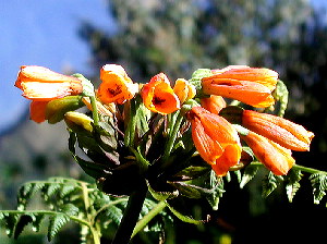
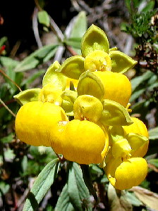
The first section of the trail goes through a similar
valley-bottom forest as we saw along the Cusichaca
valley. Only it is somewhat higher here, possibly
because of diminishing human disturbance. Officially
this forest is classified as "Submontane, Subtropical,
Very Humid Forest". Species that I noted here
include Alnus acuminata/jorulensis, Fuchsia
boliviana, Barnadesia macbridae/horrida
(Llaulli), Oreopanax ischnolobus (Maqui Maqui),
Passiflora tripartita, Piper elongatum
(Moco Moco) Rubus bogotensis, Lycopersicon
parviflorum (Climbing with yellow flowers), Duranta
armata, Stenomesson pearce (Amarylidaceae),
Clusia sp. This forest is quite dense with
an understory of ferns. |
 |
 |
Sometimes the trail comes
out of the forest and reaches into the Puna. Such
spots are good places to see butterflies. When you
dive back into the forest, it has become a "Polylepis
forest" This unique forest is dominated by Polylepis
spp (Queuña). This forest with its gnarled
trees covered with moss and a dense understory of
herbs, is quite enchanting. Around every corner you
expect a troll or at least a hobbit.
No such thing occurs here though, but the forest
is teeming with birds.
|
|
Polylepis belong to the Rosaceae family and is easily recognized by
it's pinately compound leaves with expanded petiole
base (see drawing right). The thin, flaky, reddish
bark and thick trunks with twisting branches are another
good characteristic. The genus is strictly Andean
and forming almost pure stands at altitudes that should
support Puna.
Unfortunately, Polylepis forest is one of
the most threatened forest types in the world. Originally
it covered large areas in the high Andes, but generations
of farmers burning the Puna to provide grazing for
Llamas and Alpacas have reduced the forest cover immensely.
Mature Polylepis can survive fire, but seedlings
and young trees can not. As a result, the Polylepis
forest shrinks a little after every Puna fire. For
more information see the links that I put in the left
margin. |

|
 |
Ultimately, you leave
the forest behind and come into the real Puna. This
is an open landscape dominated by grasses (Ichu).
This last stretch to the first pass is steep and strenuous.
You may see grazing Llamas and Alpacas here.
If you are lucky you may see raptors soaring above
you. The Condor is very rare and threatened by extinction,
so don't have your hopes too high for this one, but
the most common larger bird is the Mountain Caracara.
This attractive bird often allows close up looks. |
On top of the Warmiwañusca at 4265 m (13,650 ft)
you may want to indulge in a snow fight, if you have any
energy left that is. Having come so high, it is kind of
depressing to look down on the steep downward trail but
there are interesting things to see here. Just below the
pass, there is a curious collection of huge boulders, this
is where Viscachas live. These rabit-like relatives of the
Chinchilla (which is now extinct in the wild) often just
sit there on a boulder, looking rather sleepy. They are
usually so inactive that you may suspect that they are really
just stuffed animals.
At the bottom of this slope lies Pacaymayu (3500 m - 11,200
ft). This is the largest camp site along the trail and quite
a depressing place because of its frequent overcrowding.
The camp lies at the tip of a Polylepis forest that follows
the valley towards the Urubamba River, way below. This forest
shows clear signs of recent fire damage.
From Pacamayu it is up again into the Puna towards the
second pass which lies just above Runcurakay. Along the
trail grow many Odentoglossum mystacinum orchids.
|
Near the second pass (3963 m - 12,680 ft) there are
some small alpine "black water" lakes. Typically
there is hardly any vegetation in these lakes, but
some of these lakes are now filling up with vegetation.
Possibly a result of nutrient input due to vast amounts
of hikers and their porters defecating nearby?
These lakes are supposedly also good sites to see
deer, but I didn't even find any tracks of deer, so
they are probably very scarce.
|
 |
Below the second pass, you plunge back into the Polylepis
or Queuña forest. The forest is actually quite similar
to a cloud forest. As in a real cloud forest the trees are
often laden with Epiphytes such as Bromeliads and Orchids.
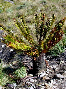
Very soon you will reach to an more open spot which actually
has a Sphagnum or Peat Bog. The vegetation here is low,
more like an "elfin forest" Many orchids and other
interesting low plants can be found here. Very characteristic
is a small treefern (or at least a fern with a trunk) that
I initially mistook to be a Cycad.
From here on, the
last stretch to Phuyopatamarca (3711 m - 11,875 ft) is not
that strenuous. Enjoy the walk and continue with part
3.

Inca
Trail Homepage
Part
1: Ollantaytambo to Wayllabamb (the lowest part)
Part
3: Phuyopatamarca to Machu Picchu (the descent)
UP
About
Belize | Administrative
| Publications | Species
Lists | Projects | HOME
|