|
The Aguacaliente Wildlife Sanctuary (AWS) National Park
is located in the Toledo district of Belize was declared
in 1998. The area covers approximately 5,468 acres of land
and water. It conservation focus is the protection of the
central wetland areas, which consist of three fresh water
lagoons and a hot spring connected by a number of creeks.
In spite of it small size is was identified of a high priority
conservation goal in the National Protected
Areas Policy and Systems Plan.
At least two ecosystems occur which are not found elsewhere
in Belize. One is a swamp forest type known as "Tropical
evergreen broad-leaved lowland swamp forest, Aguacaliente
variant" and the other is a seasonal grass land
type know as "Short-grass
swamp savanna without trees or shrubs"
The latter has suffered heavily as a result of the impact
of hurricane Iris in 2001. An impact which was compounded
by subsequent wildfires.
The protected area is co-managed by the Aguacaliente Management
Team (AMT), a consortium of people from adjacent villages.
In 2005, the AMT called for a Rapid Ecological Assessment
(REA) which was conducted out by a team under the direction
of Jan
Meerman and the final
report was completed in December 2006.

satellite
image showing the protected area (green boundary line),
note the three lagoons (dark blue blobs), The village of
Aguacaliente is to the lower right hand corner
The main objectives of the REA were:
· To produce biophysical information necessary for
development of management plans and environmental impact
assessments.
· To produce data, reports, maps, lists, classifications,
descriptions, and threats identification for management,
educational, inventory and funding purposes.
· Generate baseline data for monitoring activities
in the Park.
· Contribute to the National inventory.
· Identify species that are in danger of becoming
extinct.
· Develop preliminary data sets for future use in
inventories that are more detailed and in ecological characteristics.
· Characterize natural communities, provide descriptions
listing key species and assess their importance for conservation.
· Associate animal communities with the vegetation
types they inhabit.
· Compare diversity among different subregions of
the site.

One of the
lagoons in the Aquacaliente Wildlife Sanctuary surrounded
by flats with the grass species Neeragrostis contrerasii
.
Important feature of the
park is the tremendous change in water level. While the
above pictures were taken in April 2006, after heavy rains
in July 2006. Water levels increased dramatically. Such
heavy fluctuations completely change the outlook of the
park as can be seen from the satellite images below.
 |
 |
On July 13, 2006
the visitors center at the edge of the park was in
2 feet of water |
On July 12, 2006
much of the raised walkway was actually covered in
water |
 |
 |
|
Normal high water levels in the lagoons in
November 1999. The blue color depicts water, the pinkish
represents grass land or other open ecosystems
|
Flood levels in the lagoons in January 2004.
All of the grasslands and most of the forest is now
under water. |
Some noteworthy
plants:
 |
Hymenachne amplexicaulis. This grass is
a dominating feature between the 2nd and 3rd lagoon.
It floats in large masses in water up to 1 m deep.
is a wetland species, inhabiting margins of swamps,
river floodplains, and drainage canals,throughout
the American tropics, mostly in water to about 2 m
deep, occasionally extending into water 3-4 m deep.
It can be grown for pasture in natural or artificially
inundated pondage areas. On seasonally flooded floodplains,
it needs over 1 m of water during the wet season to
persist. It has low drought tolerance, not spreading
beyond the wet zone, and low salt tolerance, not surviving
even occasional tidal impact.
Click the image to download original image (645 kb) |
 |
This is the inflorescense of the Hymenachne
amplexicaulis grass that is a dominating feature
between the 2nd and 3rd lagoon. It floats in large
masses in water up to 1 m deep.
Click the image to download original image (1,272
kb) |
 |
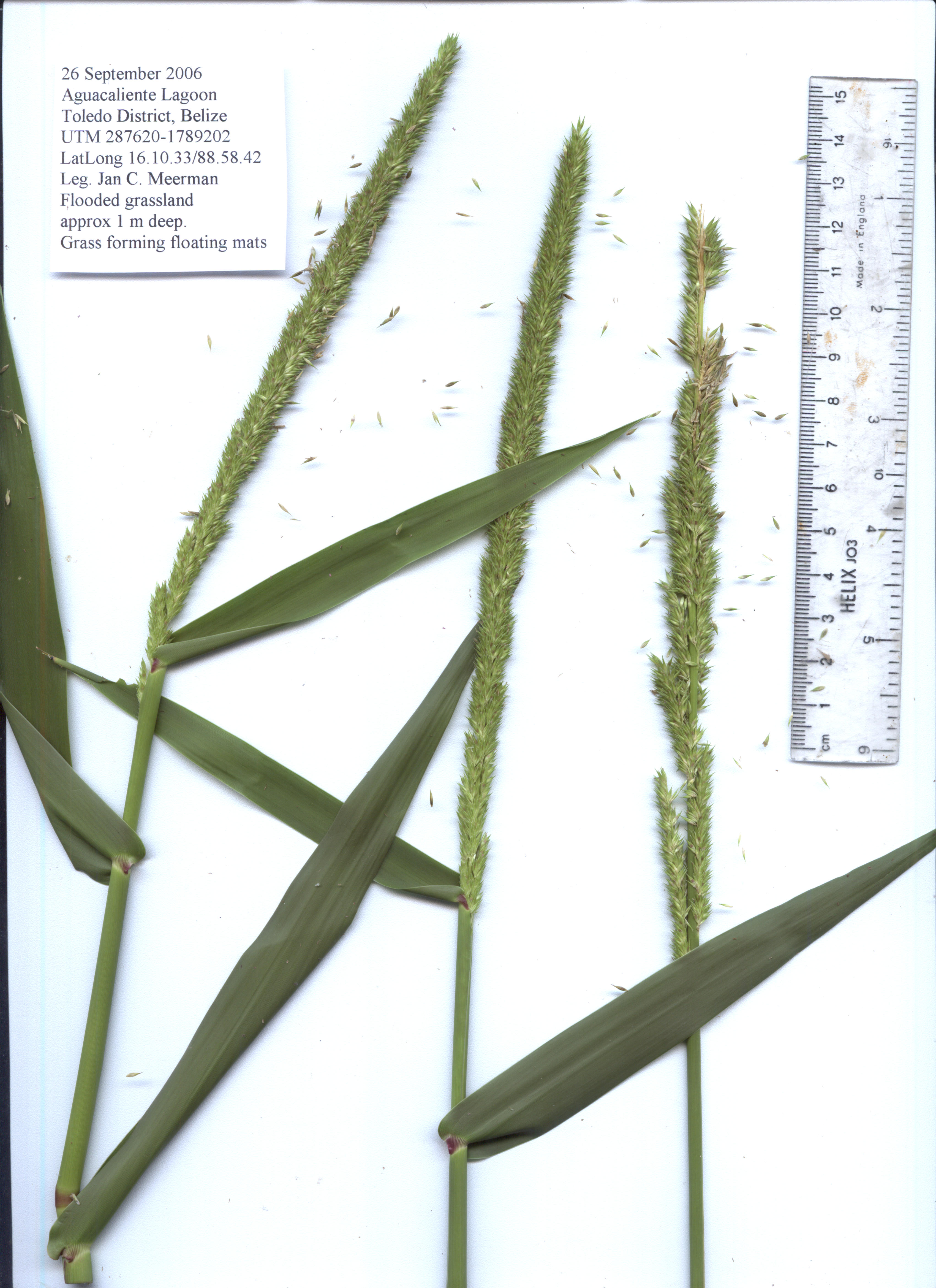
This is a scan of the Hymenachne amplexicaulis
grass which is a dominating feature between the 2nd
and 3rd lagoon. It floats in large masses in water
up to 1 m deep.
Click the image to download original image (1,366
kb) |
 |
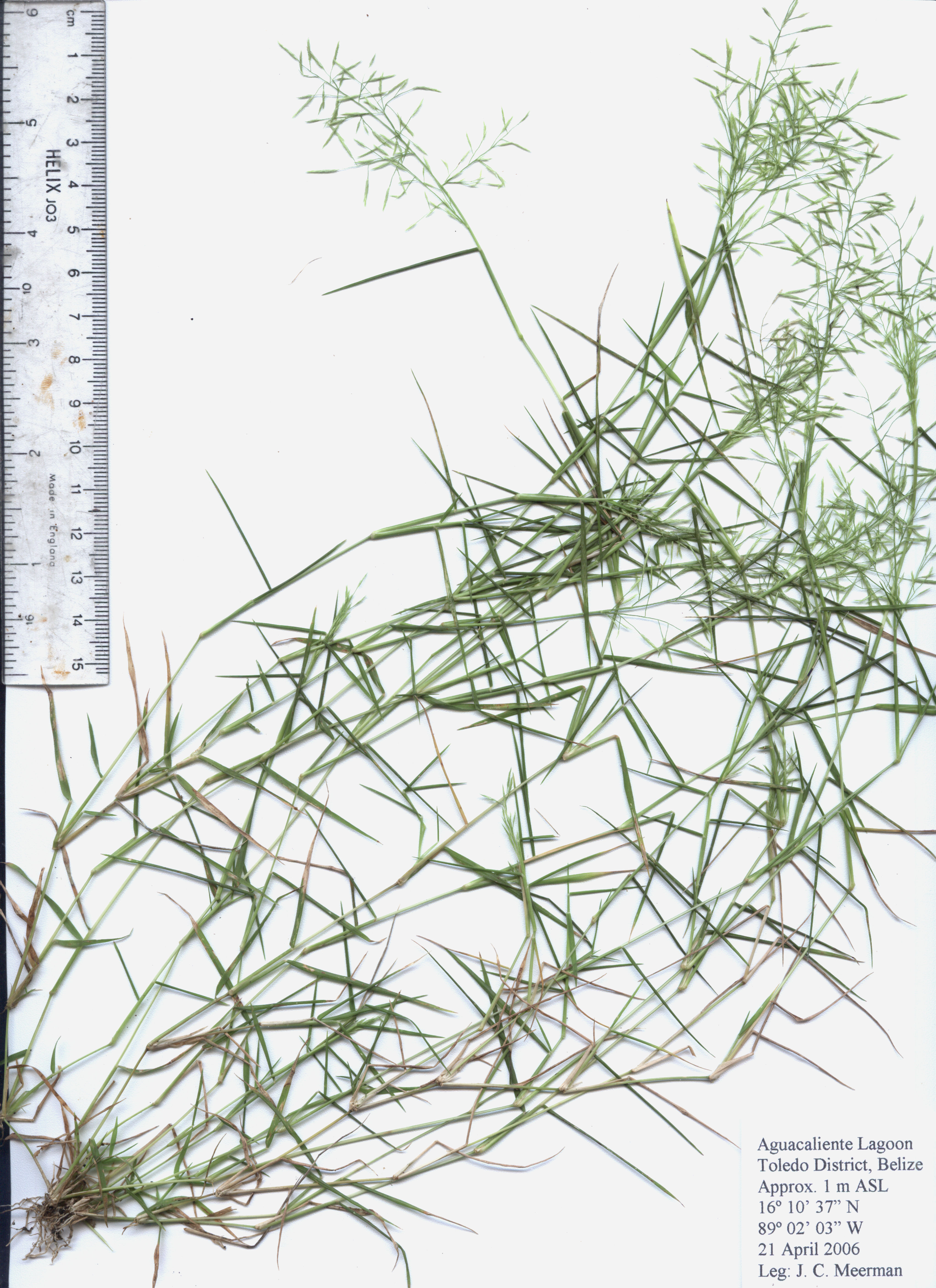
The grass around the lagoons is a really
dominating element. Unfortunately, the species has remained unidentified for a long time. But as part of the EIA, specimens were collected and now it has been established that it is Neeragrostis contrerasii.
It is clearly a very rapid growing
annual species, germinating on the mudflats in February,
flowering in April and setting seed in May.
Click
the image for a larger picture (277 kb) |
 |
This picture of Neeragrostis contrerasii
represents a scanned image. Click the image for a larger picture (2
mb) |
| |
|
 |
This water clover (really a fern): Marsilea polycarpa was found in a ricefield just outside the
Aquacaliente boundary. This is a new country
record.
Another new country record was the waterfern Ceratopteris thalictroides. Again found in a ricefield just outside the Aquacaliente boundary. |
 |
This "waterlily" is not a waterlily
at all but an arrowroot: Sagittaria guyanensis.
Yet another new country record. This
small plant is very common on the muddy trail
that leads from the village to the walkway. |
 |
Bravaisia integerrima (Acanthaceae)
is an interesting plant with prop-roots just as
in Red Mangrove (Rhizophora mangle) This species
has not previously been recorded from Belize and
so far has only been found in and around the Aguacaliente
Wildlife Sanctuary (new country record). |
Some data from the biodiversity
monitoring effort being carried out the Aguacaliente
Management Team Wardens (February through July 2006): |
 |
 |
Blue Winged Teal numbers |
Cattle Egret numbers |
 |
 |
| Roseate Spoonbill numbers |
Black-bellied Whistling Duck numbers |
 |
 |
Olivaceous Cormorant numbers |
American Woodstork numbers |
Download final report (pdf format).
Go to the Aquacaliente website
Back to top
About
Belize | Administrative
| Publications | Species
Lists | Projects | HOME
|